|
| |
|
|
|
|
|
|
|
|
|
Visibility
Research
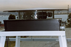
We have been involved in many aspects of research related to Visibility. At the Visibility Lab, our primary mission was the measurement of those atmospheric parameters which affect visibility. The Image Transmission section of this web site discusses the airborne measurements acquired with a military C-130 Hercules aircraft in more detail. There are also many references in the Publications section, such as Johnson et al, 1976. The Visibility Lab was involved in all aspects of visibility, including measurements of human response, propagation through the atmosphere and through the water, optical properties of visual targets, modeling of visibility, and development of one of the first powerful image processing systems. (The Visibility Lab web site provides pictures of the programs and personnel.) In addition to the atmospheric measurement program, our group was particularly involved in visibility modeling (ref Gordon, 1979) and modeling of the atmospheric effects (Hering 1981a). Members of our group are still knowledgeable about methods for determining the probability of detection of visual targets, and we occasionally consult with others in this area. Visibility is a fairly difficult parameter to measure accurately. Human estimates of visibility have been used for many years at airports and other sites. The degree to which these estimates accurately reflect the state of the atmosphere, and the scattering coefficient in particular, depends strongly on many parameters such as the size and reflectance of the visual targets being used. Transmissometers are also used extensively, and have various types of uncertainties. If the scattering coefficient of the atmosphere varies significantly, for example in different parts of an airfield, they will be limited in their ability to estimate visibility over longer paths. In response to a need for better determination of slant-path visibility, we developed a new system for determining visibility, the Horizon Scanning Imager (Johnson et al 1990, and Shields et al 1991). This was designed to determine the visibility over a distance, and provide estimates of the visibility over different sectors of the scene, ie in different directions. The device was calibrated, and by measuring the inherent contrast between each target and the background under very clear conditions, the system was able to correct for target effects. Theoretically, it should be possible for this instrument to report either the true visibility which would be obtained with large black targets, as well as an estimate of the error a human observer would incur by using the available targets.
Produced
by the Marine Physical Laboratory, SIO.
|