|
|
History
of the Atmospheric Optics Group
The Atmospheric
Optics Group has been continually involved in research related to atmospheric
optics for many decades. It began in the 1940's with studies in visibility
and contrast transmission [link to Contrast Transmission] by Dr. Seibert
Q. Duntley, as head of the Visibility Lab at MIT. Moving the group to
SIO in the early 50's, Dr. Duntley headed studies in visibility and contrast
transmission in the troposphere. Much of the Visibility
Lab was involved at that time in underwater research and image processing.
In the 60's and 70's, under Dr. Duntley and then under Richard W. Johnson,
the Atmospheric Optics Group carried out extensive experimental programs
in the airborne and ground-based measurement of sky and ground radiance
and irradiance, scattering properties, and related meteorological and
optical properties. These were tied together with related theoretical
and modeling studies of the atmosphere and contrast transmission.
|
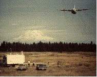
The
image at the left shows a deployment near Mt. Ranier. This photograph
was taken near the ground station as the instrumented C-130 aircraft
flew over. Both the aircraft and the ground station were instrumented
by the Atmospheric Optics Group, using instruments developed, built,
and fielded by the group. |
The Atmospheric Optics Group joined SIO's Marine Physical Lab in the mid
1980's, when the Visibility Lab closed. In the early 1980's, with the
advent of solid state imagers, we developed a series of digital Whole
Sky Imagers (WSI) for the measurement of the sky radiance and for
measurement of cloud properties. These instruments combined the characteristics
of the calibrated absolute radiance scanners
with the airborne fisheye cameras used on the C-130. However they
utilized modern solid state imaging technologies in order to acquire measurements
of the full upper hemisphere, and utilized modern computer technologies
to fully automate the data collection. Our first major deployment of a
digital WSI was in 1984. Over the next few years, several WSI's were fielded
in sites distributed throughout the USA, and a data base of cloud properties
measured once a minute over approximately 2 years at several sites was
acquired [link to CFLOS secn of Applications]. A cloud algorithm was developed
to identify the presence of clouds in the image, and much of the data
base was analyzed to extract cloud cover and cloud spatial characteristics.
Another interesting development at this time was the Horizon
Scanning Imager. Using measurements of targets of opportunity and
the measured horizon sky radiance, these instruments could determine the
slant range visibility and contrast transmittance, and the variation in
visibility around the horizon.
In the early 90's, a new generation of Day/Night
Whole Sky Imagers was developed for use under all lighting conditions,
including daylight, twilight, moonlight, and starlight. These instruments
use a very low noise 16 bit digital camera, in conjunction full hemisphere
fisheye lenses, and optical filter changers, electronic control, and computer
control systems developed at MPL. The imagers operate automatically, with
sufficient dynamic range to obtain high quality data under all natural
outdoor lighting conditions. These were originally fielded at two DOD
sites for use in Air Force, Army, and Navy applications.
In the mid 1990’s several improvements were made to the Day/Night
WSIs for use at several sites by the DOE's Atmospheric Radiation Measurements
(ARM) Program [link to ARM WSI section],
in support of climate research. These developments included much stronger
environmental housings and environmental hardening for use in such adverse
environments as the Arctic and the Tropics. Instrument self-checking capability
was added, so that the instrument could detect problems and either turn
itself off or alert the user. Filters at 800 nm in the NIR were added
for use in improved cloud algorithms. Using ideas developed initially
at MPL, our sponsors at ARM further developed the cloud algorithms using
this data and the night-time starlight data. Techniques for applying the
absolute radiance calibration data were developed at MPL and fielded,
to generate fully calibrated images of the sky.
The
late 1990’s and early 2000’s have been spent on developing
new instruments and new capabilities, as discussed in Overview
of Current Work. New instruments include a new Daytime
WSI and new miniaturized calibrated cameras for UAV's. A new field
calibration device is in development. Current analysis work includes
an analysis of Cloud Free Line of Sight statistics, improved cloud algorithms,
and new algorithms for determining earth-to-space beam transmittance.

Produced
by the Marine Physical Laboratory, SIO.
Send questions, comments and suggestions about the Atmospheric Optics
Group website to:
webmaster@mpl.ucsd.edu
Copyright © 2002.
 |
Official web page of the University of California, San Diego |
|